Sunday, November 28, 2010

Chapter 18: Hawaii


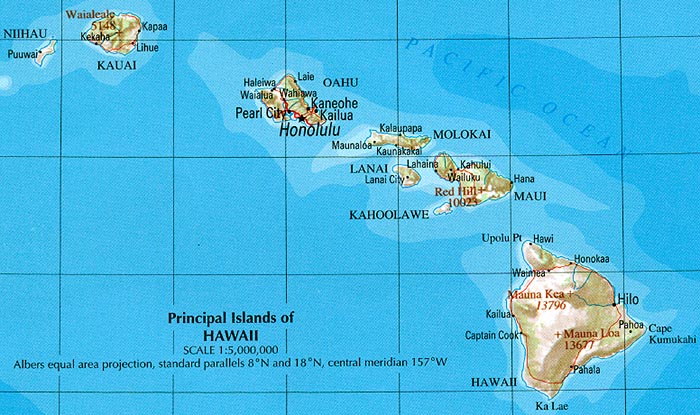
Hawaii gives us all an image of a tropical paradise. And like many others, I would like to visit the islands some day. Hawaii has eight main islands and is located near the Pacific Ocean. It is amazing to know that these beautiful islands were all created from thousands of years of volcanic eruptions and they remain to be volcanically active till this day.


  •  On the island of Honolulu stands the highest volcano of all: Diamond Head
  • Mauna Loa errupts lava about every 4 years.
  • Islands have rugged slopes and erosions of the island from the ocean waves.


The Main Islands:

  • Hawaii (The Big Island)
  • Maui (2nd largest island heavy tourism)
  • Kahoolawe (used for US Navy Military exercises)
  • Lanai (Pineapple production)
  • Molokai (half ranch land and half rugged mountains--least developed)
  • Oahu (densely populated)
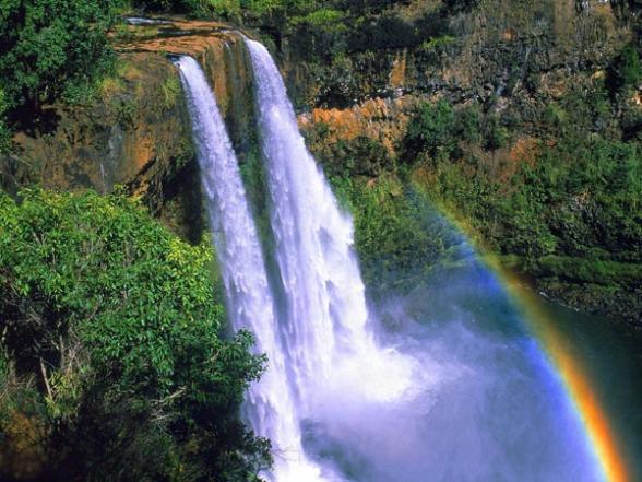
  • Kauai (known as Garden of Isle because of its breath taking sceneries)
  • Nihau (privately owned)


Like the North Pacific Coast, Hawaii can get pretty wet except they experience heavy downpours of rain in short periods of time. Honolulu can receive about 17 inches of rain in 24 hours and on some islands that made world records  with 11 inches in an hour and about 40 inches in a day.

  • The islands has dry summers from May to October and wet winters from October to April.
  • Its tropical location allows it to have little seasonal change in temperature.
  • Tropical location with warm temperatures and plentiful rain gives allows abundant plant and animal life to flourish. It's tropical forests can be quite breath taking.
Sources:

Chapter 16: The North Pacific Coast

Finally we have reached the North Pacific Coast where Seattle is part of. Although my experience living in Seattle wasn't as great as I would of liked, it is a wonderful city to visit and explore.

Seattle and the North Pacific Coast:


  • The North Pacific Coast is known for its wet climate. Cool summers, mild and wet winters.
  •  Receiving from 75 inches of rain in Northern Washington to 230 inches on the Vancouver Islands.
  • It is surrounded by rugged terrains
  • Seattle itself receives about 37 inches of rain, which isn't a lot compared to New York and a few other states. What gives people the idea that it's a rainy city is Seattle's overcast and constant drizzles.
  • The North Pacific Coast still has large areas that are considered remote.
  • Outside Seattle and around the North Pacific Coast, we can see lush forests, and vegetation because of the high precipitation


  • Seattle and Portland are considered two of the largest metropolitan in the region.
  • Beautiful site and scenery of mountains
  • Seattle is made up of mostly middle classed people; scattered neighborhoods.
  • Was home to Boeing Aircraft
  • Microsoft headquarters is located in Seattle
  • Seattle was rated one of the best cities to live in since 1989.
Despite being rated as one of the best cities to live in, Seattle's biggest problem is it's traffic. Due to its hilly terrain the Interstate 5 freeways squeezes itself into Seattle. This poses a big problem for future increase in population.


The year that lived in Seattle, I was able to experience being taken to school by a school bus (1st grade). It was very exciting for me until I did not know how to walk home from the bus stop. Seattle is considered to be hilly, although I do not remember which, I lived on one of the seven hills or hilly parts in Seattle. The school bus driver was kind enough to go off route to drop me off at my house. But it was a sight to see when this yellow school bus full of elementary kids was chugging its way up the steep hill to get to my house. I will never forget that day. 


Sources:

Chapter 15: California


I love California. Born and raised here throughout most of my life. Even though I have visited other states, nothing ever compares to California. We are blessed with a Mediterranean climate, fertile fields, a urban megalopolis, diversity of people and culture. When I moved to gloomy Seattle, I missed California's weather dearly. I've never been happier when my parents decided to move back to the Sunshine state.


Urban California

  • 90% of Californians live in one or another of California's 25 Metropolitan Statistical Areas
  • Los Angeles is the US's 2nd largest city. 
  • Most Californians reside either in Los Angeles or San Francisco. 
  • Urban megalopolis is shaped by our use of automobile thus result of heavy traffic and smog.
Ethnic Diversity
  • Southern California has become one of the main destination for immigration. 
  • 9.9 million people in county of Los Angeles.
  • Largest Mexican metropolitan outside Mexico, 2nd largest Chinese metropolitan area outside China, 2nd largest Japanese metropolitan outside Japan, largest Korean, Filipino and Vietnamese metropolitan area outside their countries.

Sources:

Chapter 14: The Southwest Border Area

We are moving closer to Seattle, but it is not part of the southwest border area. This chapter talked more about the demographics and population increase due to immigration.

Seattle is north of the southwest border area and isn't affected as much by the immigration of from Mexico. Seattle's population is predominantly white.

 Here is a quick look at Seattle's demographics.
  • White- 68.9%
  • Asian- 14.4%
  • Black- 8.2%
  • Hispanic- 6.3%
  • Native Indian- 1.2%
  • Other- 3.2%
Total Population: 536,946 people
(Source: US Census Bureau, 2005 American Community Survey)

Another thing I wanted to cover was the Native Indian population. There were many tribes in the Southwest Border area and their numbers have dwindled since the English and Spanish settlers came. When Seattle was discovered the Duwamish occupied the land. The population is still a debate but is said in 1851 when the first settler's arrived the Duwamish tribe had at least 17 villages and living in at least 90 long houses.

For 500 generations they flourished until newcomers came... much was lost; much was devalued, but much was also hidden away in the hearts of the dispossessed. Their voices insist upon a hearing and the cumulative wisdom of their long residence in this land offers rich insights to those willing to listen. The challenge now is to find a way to make knowledge of the ancient traditions, the experience of change and the living reality accessible and available.
 - David M. Buerge
Like all the tribes that existed, their lands were taken from them. The Treaty of Point Elliot was signed, however like in every tribes history, the US government failed to for fill its commitments. The Duwamish tribe never recieved their reservation. Many were forced to move from the area and join other reservations, only few stayed. In 2004 there were only about 500 Duwamish Indians left.


Here is part of the treaty (taken from Wikipedia):

ARTICLE 5.
The right of taking fish at usual and accustomed grounds and stations is further secured to said Indians in common with all citizens of the Territory,
1. To concentrate the Indians upon a few reservations, and encourage them to cultivate the soil and adopt settled and civilized habits.
2. To pay for their lands not in money, but in annuities of blankets, clothing, and useful articles during a long term of years.
3. To furnish them with schools, teachers, farmers and farming implements, blacksmiths, and carpenter, with shops of those trades.
4. To prohibit wars and disputes among them.
5. To abolish slavery.
6. To stop as far as possible the use of liquor.
7. As the change from savage to civilized habits must necessarily be gradual, they were to retain the right of fishing at their accustomed fishing-places, and of hunting, gatheringberries and roots, and pasturing stock on unoccupied land as long as it remained vacant.
8. At some future time, when they should have become fitted for it, the lands of the reservations were to be allotted to them in severalty." 
These goals were significantly different from the verbal assurances provided during negotiations, and all the Native Nations were oral cultures.


Sources:
http://www.cityofseattle.net/oir/datasheet/demographics.htm
http://www.duwamishtribe.org/culture.html
http://en.wikipedia.org/wiki/Duwamish_(tribe)

Chapter 13: The Empty Interior


Seattle is not part of the Empty Interior, however part of Washington is considered to be part of this empty region. Seattle itself is very urban, but if you head east from Seattle you will start seeing the rural parts of the Empty Interior. I found that there is a sub department in the USDA (United States Department of Agriculture) called USDA Rural Development. This department is dedicated in improving the lives of rural Americans. The depart aims to help expand the economic opportunities for rural communities by providing loans and grants and helping communities with housing, infrastructure and businesses. We see that there is a bit of persuasion or encouragement in trying to get people to move out to this part of Washington. 


(Taken from the Office of Community Development)

Typical Community Development Services we can assist with:

  • Provide technical assistance to local communities and citizen groups in strategic plan development, partnership building, and leadership development.
  • Implement programs that demonstrate effective methods of building vital rural communities.
  • Disseminate information about effective rural community and economic development strategies and methods.
  • Promote networking among rural communities and rural development practitioners.
  • Promote all USDA Rural Development programs as well as encouraging cooperation and networking with local, state, and other federal agency programs.
  • Provide training, team building and capacity building to rural communities.  Help remove barriers to development within a community by acting as facilitator and providing training and guidance regarding strategic planning, benchmarking and funding issues.

Stevenson, Washington

Hartline, Washington


Chapter 12: The Great Plains and Prairies

The Great Plains and Prairies can still be considered to be very different than that of Seattle. The Great Plains and Prairies are rural compared to Seattle's urban city. Both regions differ in climate, geography, and life style.


The Great Plains and Praries:
  • It is known for its extreme weather. Very cold winters, and very hot summers.
  • Violent storms in spring and summer with 2 inches of hail. 
  • Central Plains get an average about 24 inches of rain annually. Other places like Kansas may receive between 16-42 inches of rain. However due to it's high winds, the region's moisture evaporation and transpiration are high.
  • Blizzard and Tornado zone.
  • Despite it's extreme weather, it is still considered a major agricultural region. Provides 1/6th of our country's wheat and 1/4th of our cotton. 


Sources:

Chapter 11: The Agricultural Core

Seattle, Washington is not part of the Agricultural Core. Seattle is very urbanized compared to the rural and agrarian live style in the Agricultural Core. The farming that goes on in the core is on a much larger scale than Seattle can ever be capable of. However although on a very small scale, Seattle has it's own agriculture going on; a program the city has started on September 23, 2010 called Urban Agriculture. It is an opportunity for local sources to develop healthy food by turning your lawn and garden space into productive agricultural plots. This movement is said can help Seattle create sustainable communities and promote economic development.

"Seattle Market Gardens is a partnership between in-city farmers and consumers resulting in weekly deliveries of high-quality, farm-fresh, organic produce during the growing season."


Taken from Seattle's Department of Planning and Development. Specifically, the Department of Planning and Development (DPD) is proposing the following code changes to support and encourage urban agriculture:

  1. Add and/or clarify definitions for the following key terms: horticulture, aquaculture, animal husbandry, community gardens (including P-Patch community gardens), and urban farms.   These refined definitions have additional recommendations (below) for regulation by zone.   
  2. Allow community gardens as permitted uses in all zones, with some limitations in industrial zones.
  3. Allow urban farms in all zones as follows:

    Commercial:   Allow urban farms as a principal or accessory use.  Horticulture uses are currently limited to 10,000 sq. ft. in NC1 zones and 25,000 sq. ft. in NC2 zones; there are no size of use restrictions in NC3 or C zones.

    Industrial:      Allow urban farms as an accessory or principal use on land outside of designated MICs, and on tops and sides of buildings in all industrial zones.  Currently, horticulture uses are not allowed in industrial zones, and DPD proposes no change to this provision as based on the new definition of a horticulture use.

    Residential:    Allow urban farms as an accessory use without a permit up to 4,000 sq. ft. of planting area. Urban Farms with more than 4,000 sq. ft. of planting area would be subject to an administrative conditional use permit process.  Currently, agriculture uses are not allowed in residential zones.
     
  4. Allow rooftop greenhouses a 15 foot exception to height limits as a rooftop feature, if the greenhouse is dedicated to food production in MF/C/I/SM/Downtown zones.  
  5. Add farmers markets to the definition of multipurpose uses. 
  6. Increase the number of chickens allowed on residential property from three to eight. DPD also proposes to add that roosters are not allowed in any zone. 

Chapter 10: The Southern Coastlands

The Southern Coastlands and Seattle are total opposites places.


The Southern Coastlands:

  • Region includes from South Carolina, Florida, Georgia, Alabama, Mississippi, Louisiana, and Texas.
  • Has a subtropical climate. Humid with mild winters, and hot summers.
  • Average of 50 inches of rainfall. 
  • It's climate allows it to have at least 9 to 10 months in its agricultural growing season.
  • Socializes in citrus fruits, rice and sugarcane.
  • Prone to hurricanes. Most destructive in the Southern Coastlands. Most Recent: Hurricane Katrina. 


Thursday, October 14, 2010

Chapter 9: The Changing South

The abolition of slavery did not change any counts in Washington Territory, which had been slave-free, but the count of the Native American population was not that easy. Although nearly 15,000 Indians were counted, less than 10 percent were classified as "civilized." Besides being the first to have no slaves in its count, the 1870 census was also the first for which a Statistical Atlas was put together and published in 1872.

 United States Slave population figures, 1870

The 1870 census was one of several that tried, with little success, to accurately subdivide the "colored" population into two categories, Blacks and Mulattoes, a practice that was abandoned for good in the 1920 census. The 1870 census for Washington Territory had the following breakdown of the African American population:
  • Total of Colored "Blacks" in 1870: 56
  • Black males: 44
  • Black females: 12
  • Total of Colored "Mulattoes" in 1870: 151
  • Mulatto males: 89
  • Mulatto females: 62
Overall, and dispensing with the "black/mulatto" distinction, the racial breakdown of the population of Washington Territory in 1870 was:
  • White: 22,195 (92.64 percent of total population)
  • Colored: 207 (0.86 percent of total population)
  • Japanese: 0
  • Chinese: 234  (0.97 percent of total population)
Anti-Chinese Activism

Historians believe that Seattle's first Chinese resident was Chin Chun Hock, who arrived around 1860. He was lured by the Northwest's "Golden Mountain" and the jobs to be had here: digging mines, laying railroad tracks, and canning salmon. The Northern Pacific Railroad completed tracks from Lake Superior to Tacoma, Washington, in 1883. Two thirds of the men who laid track for the Western Division of the railroad were Chinese, a totally of almost 15,000 men across several states. The Chinese also helped construct the Seattle to Newcastle railroad.


At first, Seattle's whites welcomed the aid of the Chinese workers, but this relationship soured during the hard times of the 1870s and led to the national Chinese Exclusion Act in 1882. The Chinese Exclusion Act was the first significant law restricting immigration in the United States. Chinese immigration to the United States was suspended for 10 years, and Chinese persons were ineligible for naturalization.

sources
http://en.wikipedia.org/wiki/Seattle_riot_of_1886
http://depts.washington.edu/civilr/films&slides.htm

Chapter 8: Appalachia and the Ozarks

Seattle is nowhere near the Appalachia mountains. But it does have the Olympic Mountains and Cascade Range in its view.


Cascade Range

The Cascade Range is a major mountain range of the North Western region. It extends from southern British Columbia, Washington, Oregon and North California. The Cascades are interesting where it includes both non-volcanic mountains (known as the North Cascades) and the volcanos (known as the High Cascades). The part of the range that is in Washington is the North Cascades. The Cascades are part of what is called the Pacific Ring of Fire which are a ring of volcanoes and mountains around the Pacific Ocean.


North Cascade Range of Washington State near Mount Baker


North Cascades
  • Glacier Peak (northern Washington) — secluded and relatively inaccessible peak. Contrary to its name, its glacial cover isn't that extensive. The volcano is surprisingly small in volume, and gets most of its height by having grown atop a nonvolcanic ridge.
 Glacier Peak

High Cascades

  • Mount Rainier (southeast of Tacoma, Washington) — highest peak in the Cascades, it dominates the surrounding landscape. 
  • Mount St, Helens (southern Washington) — Erupted in 1980, leveling forests to the north of the mountain and sending ash across the northwest. The northern part of the mountain was destroyed in the blast.
  • Mount Adams (east of Mount St. Helens) — the second highest peak in Washington and third highest in the Cascade Range.
Mount St. Helens

Olympic Mountains

The Olympic Mountains is located on the Olympic Peninsula of western Washington in the US. They are park of the Pacific Coast Ranges. The highest peak would be Mount Olympus at 7,962 ft. On the west side of the mountain, it is said to be one of the wettest place in the 48 contiguous states, with an average of 142 inches of rainfall each year. On the east side it is located in a rainshadow (where Seattle is) which is much drier relative to the west. The Olympics have the form of a cluster of steep-sided peaks surrounded by heavily-forested foothills and incised by deep valleys. Sounds a little like the Appalachia doesn't it?

Olympic Mountains from Seattle


sources

Chapter 7: The Bypassed East

I wasn't able to find much connection between Seattle and the Bypassed East since Seattle is again located on the North Western part of the US. Instead I would like elaborate on Seattle's landmark: The Space Needle.


The Space Needle is a tower located in Seattle. It is a great landmark and symbol of the Pacific Northwest and of Seattle.  The two architects of the Space Needle were Edward E. Carlson and John Graham. Now at the top of the tower we have a Pacific Northwest cuisine restaurant named Sky City that rotates 360 degrees so diners are able to see the view of Downtown Seattle. The tower was built for the 1962 World's Fair and is located at the Seattle Center. It is said that during that time almost 20,000 people rode the elevators a day with 2.3 million visitors at the fair. The tower is built 605 ft high and weighs about 9,550 tons. The tower is said to be able to withstand winds up to 200 mph and with a 25 lighting rods on its roof to protect it from lightening. It was dubbed a historic landmark on April 19, 1999.


sources
http://www.u-s-history.com/pages/h3118.html
http://www.spaceneedle.com/


Chapter 5: North American Manufacturing Core


Although Seattle isn't part of the Manufacturing Core, Seattle has a history of boom and bust cycles, as is common to cities near areas of extensive natural and mineral resources. Seattle has risen several times economically, then gone into precipitous decline, but it has typically used those periods to rebuild solid infrastructure. The first booming business for Seattle was in the lumber industry in the 1800s which also earned the name "Emerald City" due to its luscious green forest. Other boom was in 1896 where gold was found in the Canadian Yukon and suddenly Seattle became a major supply transportation point for miners.

Bringing it more up to date, Seattle experienced another boom in its economy when Boeing airplane manufacturing started to dominate in the airliner market. Today Seattle is one of the cities leading toward a more green friendly urban environment. The city has one of the leading green technologies in the industry.


source
Seattle Industry
Seattle History